


Employees of the Ocean Optics Laboratory of the IO RAS Junior Researcher S.K. Klimenko and leading researcher A.Yu. Ivanov obtained interesting results on sub-satellite verification of natural oil shows detected as a result of satellite monitoring on the example of an oil show near the Maria Magdalina Bank in the Black Sea.
The shelf and the Kerch part of the Black Sea attract attention not only due to anthropogenic impact and associated pollution as a result of active navigation, but also because of the potential oil and gas content. As part of the five-year radar monitoring of the Kerch Strait and the Kerch regions, in addition to various technogenic pollution, three natural oil shows were first discovered, one of which is located at a distance of about 2.4 km southwest of the Mary Magdalene Bank and 5 .2 km from the Bugaz Spit (Fig. 1). In 2022, slicks continued to appear at the location of the oil show - they were especially extended in late July - early August 2022 (Fig. 2).

Fig. 1
Spatial-temporal grouping of spots-slicks,
found on radar images
at the Mary Magdalene Bank in 2017–2021
The natural origin of the detected slick spots on radar images (RI) was indicated by their attraction to one source and the characteristic fan structure formed by multi-temporal and multi-directional slick spots, which, depending on the currents and wind, drift in different directions (Fig. 1). In addition, in [4] it was noted that this oil show is located within the boundaries of the Kerch-Taman mud volcanic region and the Taman oil and gas region, and therefore can be a priori natural. However, a technogenic origin could not be ruled out, for example, due to leakage of oil products from some sunken ship, emissions from which are possible due to the destruction of fuel tanks (the case of leakage from the ship "Admiral Nakhimov" sunken in 1986) .

Fig. 2
Oil shows at the Mary Magdalene Bank on fragments of optical images (left)
and radar images (right) taken in July-August 2022;
the source is shown in purple. © ESA
To determine the origin of the studied oil show, verification was necessary, including sub-satellite observations of this oil show and its signatures directly in the area of interest. To do this, at the beginning of 2022, the authors turned to the EPRON military-patriotic club, which is engaged in underwater search activities in order to detect sunken ships, vessels and aircraft in the Black Sea coastal zone.
The search team was tasked with verifying the oil shows detected on the radar image and determining their status - natural / unnatural. In the course of the work, it was necessary to monitor the presence of manifestations, both on the sea surface and at the bottom of the studied area, with photo-video recording and sampling in case of detection of oil and gas manifestations.
According to remote sensing data, the oil show (the place of emergence of light oil fractions) is located at the point 45°02'08" N and 36°57'28" E, where oily films began to form on the sea surface (Fig. 2 , 3). In the course of a surface survey in this area, the presence of gas bubbles and small, up to 2–3 cm2 oily spots, which instantly blurred, forming thin oil films on the surface, were found on the sea surface (the described phenomena can be seen in photographs at the observation site in Fig. 3).
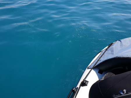
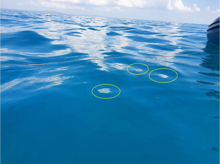
Fig. 3
Oil and gas shows in the form of gas bubbles (above)
and small slicks of oil and oily film (below) on the surface of the sea
southwest of the banks of Mary Magdalene, in the area where oil shows were detected from space.
Photo by VPK EPRON.
The maximum gas release was detected at some distance from the oil show - according to underwater surveys, the maximum gas releases were found to the northeast, at a point with the center coordinates of 45°02'12'' N. and 36°57'34''E (marked with a cross in Fig. 4). However, small single outflows of bubbles were observed throughout the entire study area, whose total area reached hundreds of square meters (the area shown by an oval in Fig. 4), and numerous gas outflows of different intensity were found at the bottom (jets of gas bubbles in the amount from one to six-seven). Soil samples were taken here for further analysis in the analytical laboratory of the IO RAS.
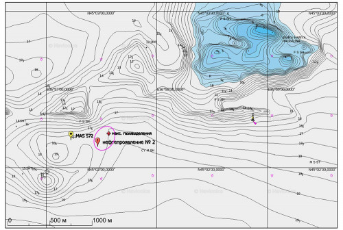
Fig. 4
The position of the oil show (No. 2) detected during radar monitoring (see Fig. 1),
the remains of a sunken torpedo boat (MAS 572) and the places of maximum gas emissions on the navigation chart;
area where scuba divers discovered numerous gas vents
of different intensity, shown by a lilac oval;
map © Navionics
The sunken ship or other possible anthropogenic sources were not found as a result of the conducted underwater research.
Based on a comparison of the obtained results with the results of monitoring in 2014–2016, a conclusion was made about the activation of underwater oil sources on the Black Sea shelf, because earlier oil shows in the Prikerchensk region of the Black Sea were not observed from space with such a frequency. We also note that outbreaks of gryphon activity were also noted in other parts of the sea, for example, on the northwestern shelf in 2018 and on the shelf of the western and southern Crimea near Sevastopol in 2019.
As noted, “an obvious reason for the activation of oil shows can be a combination of man-made and natural factors. On the one hand, there are clear signs of increasing geodynamic activity in the depths of the Black Sea. On the other hand, one cannot ignore the factor of technogenic destabilization of the subsoil as a result of oil and gas production and other types of technogenic loads. Finally, the issue of climate/global change should not be forgotten.” Thus, the reason why underwater sources began to appear at the bottom of the seas and, moreover, actively release oil and gas, deserves a more detailed study. To do this, it is necessary to study both the oil shows themselves and their sources, as well as the general geological and geophysical environment and the features of modern geodynamic activity, in which oil shows can be considered markers of such changes.
